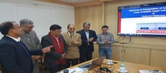
Moving a step ahead towards ensuring optimum use of National Waterways, the Inland Waterways Authority of India (IWAI) launched a new portal LADIS – Least Available Depth Information System here today.
LADIS will ensure that real-time data on least available depths is disseminatedfor ship/barge and cargo owners so that they can undertake transportation on NWs in a more planned way. An assured depth of waterway is required for seamless movement of vessels. If real time information is made available regarding LADs in stretches of various NWs, it will help transporters by guiding them on the suitability of time of movement.
The portal being hosted on IWAI’s website www.iwai.nic.in has been developed in-house. Initially LAD information will be available for NW-1, NW-2, Indo-Bagladesh Protocol route and NW-3, along with the date of survey. The facility will be expanded to other NWs also.
Details of LAD will be fed into the portal by respective surveyors and regional incharge deputed with IWAI survey vessels which constantly move on NWs.
IWAI has designed LADIS to facilitate the day to day operations of inland vessels plying on National Waterways and to avoid any hindrance in service and operation. It will enhance credibility and efficiency of information sharing to achieve seamless operations on National Waterways, besides pre-empting problems that may occur during movement of vessels.
Vessel operators/ cargo owners will prepare their sailing plans strictly as per applicable waterways related information (Hydrographic survey reports, River Notices etc.) available on IWAI’s website.