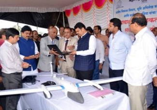
Survey of India, the national mapping agency of the country under the Min of Science & Technology has signed an MoU with Department of revenue & Land records, Govt of Maharashtra to undertake the Large scale Mapping of Village Gaothan (Aabadi) areas in the State of Maharashtra using drones.
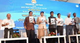
Chief Minister of Maharashtra, Devendra Fadnavis inaugurated the Drone based Mapping Project being carried out by Survey of India at Nimgaon Korhale in Ahmednagar district on 31st July, 2019.
These village Gaothan areas not been surveyed earlier will be mapped at 1:500 scale covering all land parcels in the village for preparing the accurate revenue maps and GIS database. Drone survey will be pivotal to fix locations of village boundaries, canals, canal limits and roads in these villages.
A detailed presentation about this Large scale Mapping Project was also made in the National Workshop and Conference of Sarpanch and Upsarpanch organized jointly by Department of Rural Development, Govt of Maharashtra and All India Sarpanch Association Shirdi, Ahmednagar district on 31st July. This national conference was organized under the guidance of CM Shri Devendra Fadnavis, presided by Minister of Rural Development, Women and Child Welfare Pankaja Gopinath Munde and attended by other Ministers, MP, MLAs and other dignitaries. This conference was attended by thousands of Sarpanch, Upsarpanch and farmers across the country and the Maharashtra state.
ड्रोन के जरिये महाराष्ट्र में बड़े पैमाने पर ग्रामीण क्षेत्रों का मानचित्रण किया जाएगा
विज्ञान एवं प्रौद्योगिकी मंत्रालय के अधीनस्थ देश की राष्ट्रीय मानचित्रण एजेंसी ‘सर्वे ऑफ इंडिया’ ने महाराष्ट्र सरकार के राजस्व एवं भू-अभिलेख विभाग के साथ एक सहमति पत्र (एमओयू) पर हस्ताक्षर किए हैं। इसके तहत ड्रोन के जरिए महाराष्ट्र में ग्रामीण क्षेत्रों का बड़े पैमाने पर मानचित्रण किया जाएगा।
महाराष्ट्र के मुख्यमंत्री देवेंद्र फडणवीस ने 31 जुलाई, 2019 को अहमदनगर जिले के नीमगांव कोरहले में सर्वे ऑफ इंडिया द्वारा कार्यान्वित की जा रही ड्रोन आधारित मानचित्रण परियोजना का उद्घाटन किया। बड़े पैमाने पर यह मानचित्रण परियोजना महाराष्ट्र सरकार के राजस्व एवं भू-अभिलेख विभाग के लिए भारत सरकार के विज्ञान एवं प्रौद्योगिकी मंत्रालय के अधीनस्थ‘सर्वे ऑफ इंडिया’ द्वारा कार्यान्वित की जा रही है। इसके लिए प्रोफेशनल सर्वेक्षण श्रेणी के ड्रोन का उपयोग किया जा रहा है। इसके तहत महाराष्ट्र में 40,000 से भी अधिक ग्रामीण क्षेत्रों को कवर किया जा रहा है।
गांवों की सीमाओं के साथ-साथ इन गांवों में नहरों और नहरों की सीमाएं तय करने के कार्य में ड्रोन के जरिये किया जाने वाला सर्वेक्षण अत्यंत महत्वपूर्ण साबित होगा।